Microwave sensing encompasses two types of remote sensing: active and passive. Microwaves cover wavelengths ranging from approximately 1cm to 1m in the spectrum. Microwaves, with their longer wavelengths compared to visible and infrared light, possess unique characteristics that are crucial for remote sensing. Due to their longer wavelengths, microwaves can penetrate through cloud cover, haze, dust, and even heavy rainfall, as they are less affected by atmospheric scattering, which impacts shorter optical wavelengths. This feature enables the detection of microwave energy in almost any weather or environmental condition, allowing data collection at any given time.
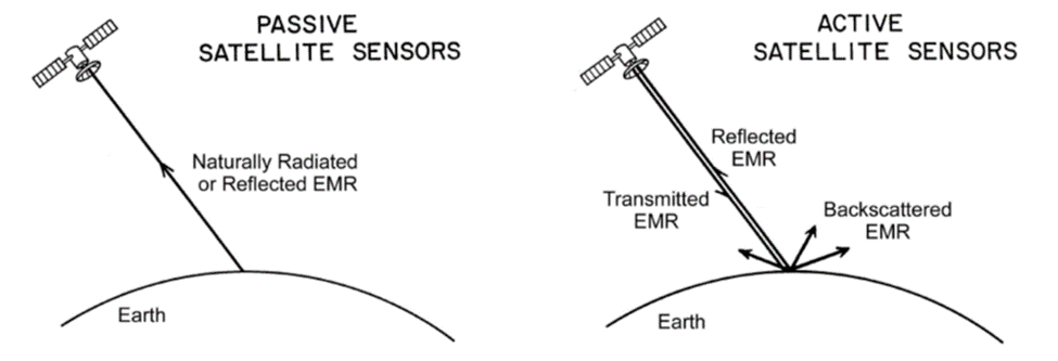
Passive microwave sensing is similar to thermal remote sensing in concept. All objects emit some amount of microwave energy, although it is generally minimal. A passive microwave sensor detects the naturally emitted microwave energy within its field of view. This emitted energy is associated with the temperature and moisture properties of the emitting object or surface. Passive microwave sensors typically function as radiometers or scanners, operating similarly to previously discussed systems, with the addition of an antenna to detect and record the microwave energy.
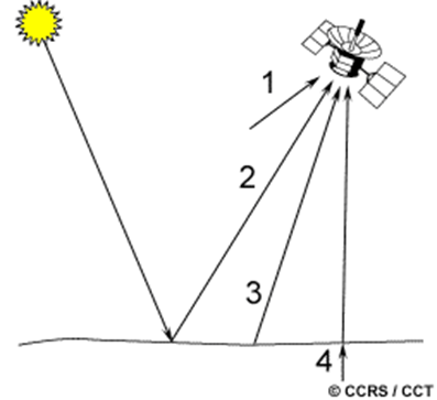
Passive sensors that record microwave energy can capture emissions from various sources: the atmosphere (1), surface reflections (2), surface emissions (3), or subsurface transmissions (4). Due to the longer wavelengths involved, the available energy is relatively small compared to optical wavelengths. Consequently, in order to detect sufficient energy for recording a signal, the fields of view of passive microwave sensors need to be large. As a result, these sensors are typically associated with low spatial resolution.
Passive microwave remote sensing finds application in various fields such as meteorology, hydrology, and oceanography. Meteorologists utilize passive microwaves to measure atmospheric profiles, determine water and ozone content in the atmosphere, and observe atmospheric conditions depending on the wavelength used. Hydrologists make use of passive microwaves to measure soil moisture as microwave emission is influenced by moisture content. In oceanography, passive microwave remote sensing aids in mapping sea ice, studying currents and surface winds, and detecting pollutants like oil slicks.
On the other hand, active microwave sensors provide their own microwave radiation to illuminate the target. Active sensors can be categorized into imaging and non-imaging sensors. Imaging active sensors, like RADAR (RAdio Detection And Ranging), transmit microwave signals towards the target and detect the backscattered portion of the signal. This enables discrimination between different targets based on the strength of the backscattered signal and determination of the target’s distance by measuring the time delay between the transmitted and reflected signals.

Non-imaging microwave sensors, such as altimeters and scatterometers, primarily perform profiling measurements along a single dimension. Radar altimeters use short microwave pulses to measure the round trip time delay and determine the distance from the sensor to targets, providing height or elevation information. Scatterometers quantify the amount of energy backscattered from targets, which depends on surface properties and the angle of incidence of the microwave energy. Scatterometry over ocean surfaces can estimate wind speeds based on sea surface roughness. Ground-based scatterometers are used to measure backscatter accurately and characterize different materials and surface types, analogous to spectral reflectance curves in the optical spectrum.
Unlike passive sensing, which relies on natural emissions, active radar has the advantage of being able to penetrate through cloud cover and operate day or night. This makes it suitable for all-weather imaging. Additionally, radar and optical data offer different perspectives and information about the Earth’s surface, making them complementary to each other. The origins of imaging radar trace back to the early 20th century, and after World War II, the technology progressed from military applications to civilian mapping and monitoring purposes. Canada became involved in radar remote sensing in the 1970s, recognizing its potential for surveillance and resource monitoring in the Arctic region. Over the years, research and commercial radar systems have collected extensive imagery, and the launch of various spaceborne radar satellites further expanded the capabilities of radar remote sensing.